Latitudes is any circle whose plane is perpendicular to the axis of the earth. The greatest latitude is the equator that divides the earth into two equal parts with planes of the two parts perpendicular to the axis.
Latitudes are identified by the angle turned North or South upto 90o in each case about the center of the earth starting from the plane of the equator. Equator is taken to be the reference point for all the other latitudes and is thus 0oNorth or 0o South.
The radius r of any latitude at an angle θ relative to the equator is given as r = Rcosθ where R is radius of the equator. It is easy to see that radius of the latitudes decreases as one moves from the equator towards the poles
Equator is the only great circle among the circles of latitudes.
All other circles of latitudes are parallel to the equator and are measured in degrees north or south of Equator.
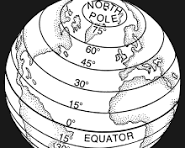
The figure below shows P on Latitude 40oN and Q 70oS.

The radius of latitude P is given by R cos40o where R is radius of the earth.
Radius of Q will be given by R cos70o
Lines of latitude are also known as horizontal mapping lines as they are perceived to be in horizontal direction with relative to the earth’s axis.
They are are referred to as parallels of latitude as the run parallel to the equator.
The angle of a latitude is number of degrees from the center of the sphere with equator as the reference line.
A line is drawn from the center of the earth against the equator line to a point on the Earth’s surface on the latitude which we need.
Equator is the reference point for all other circles of latitudes and it is considered to be at 0o.
Consider a point A on the Earth’s surface located at angle θ north of equator and another point C located at angle α to the south of Equator as shown in figure below.

B is the reference point which is also the equator.
The angle θ subtended by the arc AB at the center of the earth is the latitude of the circle passing through point A north and parallel to the equator.
Angle α is the latitude of the circle passing through C parallel and to the south of equator.
Latitude lines are a numerical way to measure how far north or south of the equator a place is located. equator is the origin point hence marked as 0 degrees latitude. The number of latitude degrees will be larger the further away from the equator the place is located where the farthest place is on 90o latitude. Latitude locations are given as θ degrees North or α degrees South.
. see the figure below.

Example
In the figure below, A, E and B are on the same longitude and the angle between OA and OE is 40o where O is the center of the earth and E is a point on the equator which is on the same longitude as A.

Since A is due north of E, we write the latitude of A as 40oN. Similarly, the latitude of B is 55oS.
A and B are on the opposite side of the equator and Therefore the angle between them is the angle is the angle AOB given by <AOB = 40o+55o = 95o.
The angle between Latitude A and B is referred to as the latitude difference.
Consider a latitude C(20oN). The difference between A(40oN) and C(20oN) is 40o-20o = 20o.
Note: If two latitudes are on the same side of the equator, the angle between them is the difference in angle of the two latitudes.
The difference between B(55oS) and C(20oN) will be 55o + 20o = 75o .
Please note that when two latitudes are on the opposite side of equator, the angle between them is the sum of their latitudes.
Related posts
- Longitudes and latitudes
- Magnetic effect on current
- matrices of transformation
- Trigonometric ratios
- solving triangles with tangents
- The tangents of an angle